Unlock the Future of Indoor Mapping: How NavVis Technology Delivers Unmatched Accuracy and Efficiency for Complex Spaces. Discover the Game-Changing Features Transforming Digital Twin Creation and Facility Management.
- Introduction to NavVis Indoor Mapping Technology
- Core Features and Capabilities of NavVis Solutions
- How NavVis Achieves High-Precision Indoor Mapping
- Applications Across Industries: From Construction to Facility Management
- Integration with Digital Twins and BIM Workflows
- Case Studies: Real-World Success Stories with NavVis
- Comparing NavVis to Competing Indoor Mapping Technologies
- Future Developments and Roadmap for NavVis
- Conclusion: The Impact of NavVis on the Indoor Mapping Landscape
- Sources & References
Introduction to NavVis Indoor Mapping Technology
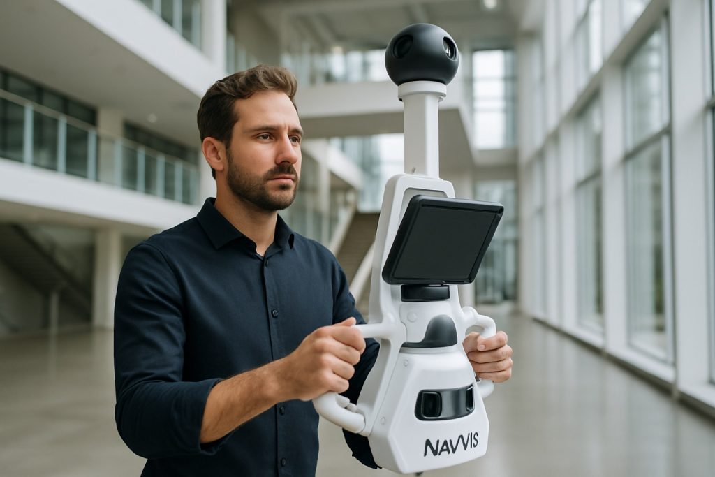
NavVis Indoor Mapping Technology represents a cutting-edge solution for capturing, visualizing, and managing indoor spatial data. Unlike traditional mapping systems that focus on outdoor environments, NavVis specializes in the complexities of indoor spaces, providing high-precision 3D mapping and digital twin creation for buildings, factories, and large facilities. The technology leverages advanced mobile mapping devices equipped with LiDAR sensors, high-resolution cameras, and simultaneous localization and mapping (SLAM) algorithms to generate accurate, photorealistic representations of interior environments in real time.
A key advantage of NavVis technology is its ability to rapidly scan large indoor areas with minimal disruption to ongoing operations. The resulting data can be accessed and navigated through intuitive web-based platforms, enabling stakeholders to remotely explore, measure, and annotate spaces as if they were physically present. This capability is particularly valuable for industries such as construction, facility management, manufacturing, and real estate, where up-to-date spatial information is critical for planning, maintenance, and collaboration.
NavVis also supports seamless integration with Building Information Modeling (BIM) and Geographic Information Systems (GIS), enhancing workflows and decision-making processes. The company’s solutions are trusted by global enterprises and have been deployed in diverse environments, from airports and hospitals to automotive plants and cultural heritage sites. As digital transformation accelerates across industries, NavVis Indoor Mapping Technology is poised to play a pivotal role in bridging the gap between physical and digital spaces, driving efficiency and innovation in the built environment (NavVis).
Core Features and Capabilities of NavVis Solutions
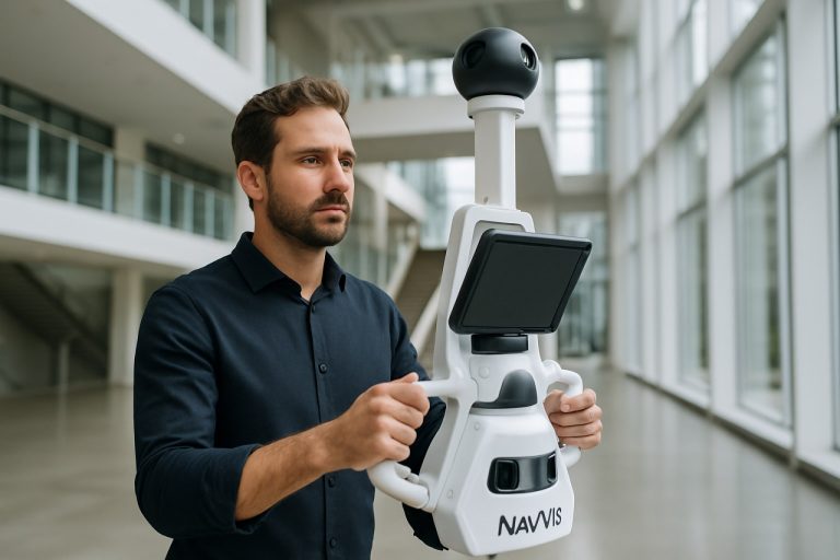
NavVis indoor mapping technology is distinguished by a suite of advanced features and capabilities that set it apart in the field of reality capture and digital twin creation. At its core, NavVis solutions utilize mobile mapping systems equipped with high-resolution LiDAR sensors and panoramic cameras, enabling rapid and accurate 3D data acquisition of complex indoor environments. The flagship device, NavVis VLX, is a wearable mobile mapping system that allows operators to walk through spaces, capturing detailed spatial data in real time. This approach significantly reduces the time and labor required compared to traditional static scanning methods.
A key capability of NavVis technology is its simultaneous localization and mapping (SLAM) algorithm, which ensures precise positioning and alignment of captured data even in GPS-denied environments such as large buildings or industrial facilities. The resulting point clouds and panoramic imagery are processed and visualized through the NavVis IVION platform, which offers intuitive web-based access, measurement tools, and annotation features for stakeholders across disciplines. Integration with BIM and CAD workflows is seamless, supporting formats like E57, LAS, and Revit, which streamlines the transition from reality capture to actionable digital models.
Additional features include automated floorplan generation, change detection, and the ability to georeference scans for alignment with existing site data. NavVis solutions also support multi-user collaboration, allowing teams to remotely explore and interact with digital twins. These capabilities make NavVis a powerful tool for industries such as construction, facility management, and manufacturing, where accurate, up-to-date spatial information is critical for decision-making and operational efficiency (NavVis VLX, NavVis IVION).
How NavVis Achieves High-Precision Indoor Mapping
NavVis achieves high-precision indoor mapping through a combination of advanced hardware, sophisticated software algorithms, and robust data processing workflows. At the core of NavVis technology is the use of mobile mapping systems, such as the NavVis VLX, which integrates multiple LiDAR sensors, high-resolution cameras, and inertial measurement units (IMUs). These sensors work in tandem to capture dense 3D point clouds and panoramic imagery as the operator moves through indoor environments. The LiDAR sensors provide accurate distance measurements, while the IMUs track movement and orientation, ensuring spatial consistency even in complex or GPS-denied settings.
A key factor in achieving high precision is NavVis’s proprietary Simultaneous Localization and Mapping (SLAM) algorithms. These algorithms process the raw sensor data in real time, aligning and stitching together point clouds to create a unified, georeferenced 3D model. The SLAM technology is optimized to handle the unique challenges of indoor spaces, such as repetitive architectural features and dynamic obstacles, minimizing drift and maximizing accuracy. Additionally, NavVis employs rigorous calibration procedures and quality assurance checks to further enhance data reliability.
Post-processing software, such as NavVis IVION, enables users to refine, visualize, and share the captured data. This platform supports automated feature extraction, floor plan generation, and integration with Building Information Modeling (BIM) systems, ensuring that the final outputs meet the high standards required for applications in construction, facility management, and digital twin creation. The combination of cutting-edge hardware, intelligent algorithms, and user-friendly software positions NavVis as a leader in high-precision indoor mapping technology NavVis Geospatial World.
Applications Across Industries: From Construction to Facility Management
NavVis indoor mapping technology has rapidly gained traction across a diverse range of industries, offering transformative solutions for sectors such as construction, facility management, manufacturing, and retail. In the construction industry, NavVis enables precise as-built documentation and progress monitoring by capturing high-resolution 3D scans of building interiors. This allows project stakeholders to compare actual site conditions with digital plans, identify discrepancies early, and streamline communication between teams, ultimately reducing costly rework and delays (NavVis).
For facility management, NavVis provides a digital twin of indoor environments, facilitating efficient space utilization, maintenance planning, and asset tracking. Facility managers can access up-to-date floor plans and immersive 3D walkthroughs, enabling remote inspections and more informed decision-making. This is particularly valuable for large or complex sites, such as hospitals, universities, and corporate campuses, where traditional manual surveys are time-consuming and prone to error (NavVis).
In manufacturing, NavVis technology supports layout optimization, equipment installation, and safety compliance by delivering accurate spatial data and visual documentation. Retailers leverage NavVis for store planning, inventory management, and customer experience enhancements, using detailed indoor maps to optimize layouts and streamline operations. The adaptability and scalability of NavVis solutions make them suitable for both small-scale projects and enterprise-level deployments, underscoring their growing importance in digital transformation initiatives across industries (NavVis).
Integration with Digital Twins and BIM Workflows
NavVis indoor mapping technology plays a pivotal role in the integration of spatial data with digital twins and Building Information Modeling (BIM) workflows. By capturing high-resolution, georeferenced point clouds and panoramic imagery, NavVis systems enable the creation of highly accurate digital representations of indoor environments. These datasets can be seamlessly imported into BIM platforms, such as Autodesk Revit or Bentley Systems, facilitating the synchronization of as-built conditions with design models. This integration supports a range of applications, from construction progress monitoring to facility management and renovation planning.
A key advantage of NavVis technology is its compatibility with open data standards, such as Industry Foundation Classes (IFC) and BuildingSMART protocols, which ensures interoperability across various BIM and digital twin ecosystems. The NavVis IndoorViewer and NavVis IVION platforms provide intuitive web-based interfaces for visualizing, annotating, and sharing spatial data, making it easier for stakeholders to collaborate and make informed decisions based on up-to-date site conditions. Furthermore, NavVis offers APIs and SDKs that allow for the automation of data transfer and the development of custom integrations with enterprise asset management or IoT platforms, enhancing the value of digital twins for operational workflows.
By bridging the gap between physical spaces and their digital counterparts, NavVis technology accelerates the adoption of digital twins in the architecture, engineering, and construction (AEC) industry, supporting lifecycle management and enabling data-driven decision-making. For more information, see NavVis and buildingSMART International.
Case Studies: Real-World Success Stories with NavVis
NavVis indoor mapping technology has been successfully deployed across a range of industries, demonstrating its versatility and impact in real-world scenarios. One notable case is its use by Siemens for the digitalization of manufacturing facilities. By leveraging NavVis mobile mapping systems, Siemens was able to rapidly capture highly accurate 3D data of complex factory environments, enabling efficient space management, process optimization, and the integration of digital twins into their operations.
In the construction sector, Royal BAM Group utilized NavVis technology to streamline project documentation and progress tracking. The ability to generate detailed, up-to-date indoor maps allowed project teams to remotely inspect sites, reducing the need for frequent site visits and minimizing errors due to outdated information. This resulted in improved collaboration among stakeholders and significant time savings during project execution.
NavVis has also played a pivotal role in the cultural heritage sector. The Bavarian National Museum adopted NavVis indoor mapping to create immersive virtual tours and detailed digital archives of its exhibits. This not only enhanced visitor engagement but also provided a valuable resource for preservation and restoration efforts.
These case studies underscore the adaptability and effectiveness of NavVis indoor mapping technology in addressing diverse challenges, from industrial optimization to cultural preservation. The technology’s ability to deliver precise, comprehensive spatial data has made it a trusted solution for organizations seeking to innovate and improve operational efficiency across various domains.
Comparing NavVis to Competing Indoor Mapping Technologies
NavVis Indoor Mapping Technology distinguishes itself in the competitive landscape of indoor spatial data capture through its unique combination of mobile mapping systems, advanced SLAM (Simultaneous Localization and Mapping) algorithms, and high-fidelity visualization tools. Unlike traditional static terrestrial laser scanners, which require multiple setups and are time-intensive, NavVis’s mobile mapping devices—such as the NavVis VLX—enable rapid, continuous data collection while walking through complex environments. This mobility significantly reduces mapping time and operational disruption, a key advantage over static systems from companies like Leica Geosystems and FARO Technologies.
Compared to other mobile mapping solutions, such as those offered by GeoSLAM, NavVis stands out for its integration of high-resolution panoramic imagery with LiDAR point clouds, providing both geometric accuracy and rich visual context. The NavVis platform also features cloud-based processing and visualization via NavVis IVION, enabling seamless collaboration and data sharing, which is less developed in some competing systems.
Furthermore, NavVis’s SLAM technology is optimized for large, complex indoor spaces, maintaining accuracy even in environments with repetitive architectural features where other systems may struggle. Its ergonomic hardware design and user-friendly workflows also lower the barrier for non-expert operators. While competitors may offer specialized features—such as backpack portability or integration with specific BIM platforms—NavVis’s holistic approach to speed, accuracy, and usability positions it as a leader in the indoor mapping sector.
Future Developments and Roadmap for NavVis
The future of NavVis Indoor Mapping Technology is shaped by rapid advancements in sensor technology, artificial intelligence, and cloud-based data processing. NavVis has outlined a roadmap that emphasizes greater automation, improved data accuracy, and enhanced integration with digital twin platforms. One key area of development is the expansion of real-time mapping capabilities, enabling users to generate and update indoor maps dynamically as environments change. This is particularly relevant for industries such as manufacturing, logistics, and facility management, where spatial data must remain current to support operational efficiency.
Another significant focus is the integration of NavVis technology with Building Information Modeling (BIM) and Geographic Information Systems (GIS). By streamlining workflows between NavVis indoor mapping outputs and BIM/GIS platforms, the company aims to facilitate seamless data exchange and more effective lifecycle management of buildings and infrastructure. Additionally, NavVis is investing in cloud-based collaboration tools, allowing stakeholders to access, annotate, and share spatial data remotely, which is increasingly important in a hybrid work environment.
Looking ahead, NavVis is also exploring the use of machine learning to automate feature extraction and anomaly detection within mapped environments. This will reduce manual post-processing and enable faster decision-making. The company’s commitment to open standards and interoperability suggests that future developments will prioritize compatibility with a broad ecosystem of software and hardware solutions. As outlined in their recent product updates and strategic announcements, NavVis is positioning itself to be at the forefront of the digital transformation of indoor spaces, supporting the evolution of smart buildings and Industry 4.0 initiatives (NavVis Technology Roadmap).
Conclusion: The Impact of NavVis on the Indoor Mapping Landscape
NavVis Indoor Mapping Technology has significantly transformed the landscape of indoor spatial data acquisition and utilization. By integrating advanced mobile mapping systems, such as the NavVis M6 and VLX, with robust software platforms, NavVis has enabled rapid, accurate, and highly detailed 3D mapping of complex indoor environments. This technological leap has streamlined workflows in industries ranging from construction and facility management to manufacturing and retail, allowing stakeholders to make data-driven decisions based on precise digital twins of their assets.
The impact of NavVis extends beyond mere efficiency gains. Its solutions have democratized access to high-quality indoor spatial data, reducing the barriers to entry for organizations of all sizes. The seamless integration of point cloud data with Building Information Modeling (BIM) and Geographic Information Systems (GIS) has fostered greater collaboration and transparency across project teams. Furthermore, the ability to remotely access and interact with immersive digital environments has proven invaluable, especially in scenarios where on-site visits are impractical or costly.
As the demand for smart buildings and digital transformation accelerates, NavVis continues to set new standards for accuracy, scalability, and usability in indoor mapping. Its ongoing innovation is shaping the future of how indoor spaces are captured, analyzed, and managed, positioning NavVis as a pivotal player in the evolution of the built environment. For more information, visit NavVis.
Sources & References
- NavVis
- Geospatial World
- buildingSMART International
- Siemens
- Royal BAM Group
- Bavarian National Museum
- FARO Technologies
- GeoSLAM


